Showing posts with label Trekking. Show all posts

30 December 2006

Long Jelet

Our short hike ended in the tiny village of Long Jelet. This little kampung consists of approximately 70 people and a few dozen wooden houses. The locals are, by far, the most self-sustaining peoples I've ever met. They produce all their own rice through rotation swidden farming and their protein is caught with nets, shot with guns are speared. They cultivate vegetables in their yards or gather them from the surrounding forest. The materials from their houses come from the forest, even their backpacks are woven from locally gathered rattan. They do buy coffee, tea, sugar and gas for their boat engines and there's the occasional satellite TV. To pay for these items many of the villagers take the 5 day trek which brings them to Malaysia where they generally find work on palm oil plantations and send home the money.

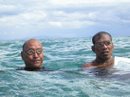
A group of villagers greeted us with strong handshakes and smiles as we entered the village. This was a phenomenal improvement to our experience in Long Pujungan where the people were not overtly happy to see us invading their little haven and we began to wonder if the locals actually wanted tourists. WWF has done a great job with hospitality training in the kampung of Long Jelet. We were then whisked away to our host family's house which was home to a young couple and their adorable one year old son who stumbled about the house with beads wrapped around his calves, arms and neck.

The head of the local ecotourism committee was eager for us to get outside and about an hour after arriving we had already arranged our next excursion. There wasn't many options available to us, since we didn't want to pay around 300,000 Rupiah for a 15 minute boat ride and most of the trips involved riding on a boat, so we decided to head to a nearby waterfall. We were told that this waterfall would be a mere 2 hour, easy trek which tells you how often tourists visit the waterfall. What was suppose to take half a day ended up being a full day of hiking. It's not so much that the waterfall was far away. It took us that long because we hiked along a foot wide path which was hacked out of a very steep sloping mountain. It took all of our energy just not to fall down the mountain as we scampered about trying to keep up with the rest of the crew. Clearly the locals were not used to seeing those who lead a sedentary lifestyle try to balance over slippery moss covered rocks. They pranced over the stones like they were strolling on an even cement sidewalk. We were constantly eating their dust. Exhausted, we arrived at the waterfall where everyone got picture happy. They love posing! My favorite was our grandfather guide who is a skilled rattan weaver. Watching him changing poses next to the waterfall was the highlight of the day. After the picture-picture one of the men persuaded us to join him in a dip in the pool at the base of the waterfall. Then we had to rush back across the mountain in order to make it home before dark.

The Good Life
After the exhausting hike to Long Jelet followed by the harrowing trek to the waterfalls we decided our poor feet deserved a break from the terrible rubber shoes. So, we took a day of rest. We had a leisurely breakfast of extreme fried fish and rice. We lounged around reading a watching the little boy run around with a large grin on his face.


In the afternoon some of the locals took us on a small river tour. They brought along their cast nets and woven rattan backpacks and fished the river. We were also lucky enough to partake in the action. I've seen cast net thrown numerous times, and the men who wield them always do so with such calm and easy composure. But I'll tell you one thing...this is no simple task. The base of the net is strung through metal chain, which is heavy! It took us some time to figure out how exactly to hold the net and it was difficult to keep my chain-laden arms up for so long. A few times during the throw, I thought either one of us would land face first in the water. It was a tough job and though our attempts were entertaining to watch they were by no means fruitful. Thankfully, we had with us a pair of skilled fishermen who filled the woven backpacks with delicious freshwater fish of all shapes and sizes.

We awoke the following day to rain. That's right folks, the rainy season had finally begun, much to our dismay. It was also pouring every night. Ugh.

Because of the rain, we decided to rest again. In the afternoon the village leader took us on a search for some animals. We were hoping to see some monkeys and deer but we're not very good trackers, though our guide was. He saw a deer or two but each time he tried to point them out we failed to see them hidden in the brush. On the way back he stopped to gather some vines for dinner. It was amazing watching him work the machete around the very spiny vines. He worked so smoothly and deftly, quickly removing the out thorns to uncover the white insides. Then he took us on an interesting journey through the ferns back to the village.

Mealtime
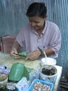
Our hostess was amazing. Before every meal she would separate the warm rice into portions and pack them in large leaves. She would also heat up the main dishes, which usually consisted of leftovers, so we always had piping hot food to fill our tummies. She then laid the amazing meaty spread on the floor of the large common room and we would eat our meal with our hands while seated on the wooden floor. Beside the main dishes, she would place a small bowl full of hand crushed fresh chili peppers mixed with salt which we would sprinkle on our food to give added flavor and warmth.

One day, some pork showed up at a meal. It had been boiled so tender that it literally melted in one's mouth. The taste was richer and stronger than any pork we'd ever tasted and the meat was lean. Someone (our host?) had killed the wild pig and brought it to our home (perhaps split it between a number of households?). Subsequently, we ate pig at every meal for the next 3 days. What we didn't finish the first day was put back into the kettle and left near the constantly roaring fire. Just before mealtime our hostess would place the pot over the fire to heat the meat before serving. This was repeated numerous times and the meal became more delicious with each day.

Besides wild boar, we also were served numerous wild plants which had been gathered in the jungle. Once we were served the insides a large, spiky rattan-like vine, which tasted bitter. We also had chopped up leaves and ferns. From the farrow rice paddies we picked unripened pineapple and made a fiery chili pineapple salad.

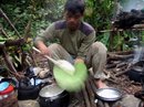
Undoubtedly one of the staples is deep fried fish. This is because the fish are easier to catch than the forest animals. One day our host took his boat out for about an hour and came home with enough fish to feed us for 2 days. All fish caught were eaten and these included large suckers as well as smaller fish.

The Journey Home
Each day we awoke we were unsure about how long we'd get to stay in the beautiful backwater. We knew we needed to make it out of Long Punjungan by a certain date in order to make it out of the country before our visa expired, but no one could tell us exactly when the downriver boats would be setting sail. Since we'd have to leave Long Jelet a day before the boats left, our length of stay in Long Jelet was dependent on the very loose trip schedule. We were told that there would surely be boats on the weekend, but no boats left. Everyday was a new story and it began to worry us.

We had planned to take a boat from Long Jelet to Long Punjungan to save us the energy of another 1.5 day hike. But, because of the unexpected change in the weather (ie rain) we were told one morning that the river was raging over the rapids with such voracity that the small motor boats were unable to ply its waters. In effect, the people of Long Jelet (us included) were trapped. This was not a new phenomenon and it seemed not to phase the locals in the slightest. The head of the ecotourism committee new of our situation and gave us two options: We could wait out the rain and see if the river dropped enough before the expiry date on our visa or we could return the way we came, on foot and through the hills. Though he gave us the options, it was clear he would rather us hike out of Long Jelet, the much safer of the two options. This meant however, that we would be leaving in just a few hours for another feet-killing journey. This did not make Lora happy, who was content in the warm wooden hut. Soon the rain stopped and two guides were rounded up to take us on our trek.

The first day was up a steep hill and then back down. Again, the guides shot a female barking deer. They cut the meat up nicely and grilled a leg over the fire. The rest of the meat (no inners! Yea!) they through in a pot and boiled.

The next day we got up early and broke down camp. As usual we heard the occasional crash of an animal running away in the distance. When we reach a shoulder in the uphill climb the sounds of gibbons we had been following grew steadily louder. One of the guides, who was skilled at animal mimicry began calling back to the gibbons. We put our bags down and rushed up farther to see if we could catch a glimpse at these graceful creatures. Sure enough, they had been swinging along the path and we had a wonderfully clear view of them as they glided through the trees. We were even lucky enough to watch one of the pair make a u-turn and swing back toward us. Unfortunately, we were both so stunned by the awesomeness of the moment that neither one of us snapped any pictures. Never mind, the pictures could never have turned out as perfect as my memories of the primates.

We had to walk hard and fast the rest of the trip in order to make it all the way back to Long Pujungan before dark. It was imperative that we make it to the town because the next day we needed to be on the boat down river. Exhausted, we made it to town just as it became to dark to see without light. We spent the night in an extremely overpriced guesthouse and got on the same boat that took us upstream. We were sad to leave this place, but happy that the journey had left us with so many good memories.

15 December 2006

The Forest Affliction


When trekking through the tropical rainforest one will generally lose some blood. This is almost completely unavoidable as the swarms of leeches attack from below. The troops gather strength after the rains (which happens often in RAINforest). Then creep across the ground cover silently and can play "twig" was unsuspecting ease. Swiftly but undetectably they attach themselves to whatever appendage come closest to their hiding place: shoe, calf, thigh and even arms are subject to such attacks. Stealthily they worm their way to the most tender skin. They relish the ankles, between the toes and when they can travel so far, between the thighs and buttocks. Their bites are often unnoticed, except for the time they hit the exceptionally tender locations such as the groin or armpit. One may not even notice they're there until satiated, they drop from the body leaving small wounds that gush crimson blood and stain clothing. Later, after the wounds have scabbed over, they will itch incessantly.

The locals, who are forced to live among these merciless creatures have come up with numerous ways to deter them. Almost everyone who travels past their yard equips themselves with leech socks, knee high tightly woven socks that the leeches are unable to penetrate. Those going deep into the recesses of the forest, such as hunters, will rub tobacco on their shoes and legs. Tobacco, suprisingly is a powerful insecticide which will kill leeches who crawl onto its juices. Then, to be extra safe, they spray the insides of their shoes and their socks with Baygon mosquito repellant. This combination works beautifully at killing 90% of all leeches that try to attack. It is wonderful searching one's boots for the number of fatalities still attached. These numbers are always high: 14, 20, 30 fatalities in a few hours. Yet some always manage to slip past the barriers...

Jungle Survival


Shortly after arriving in Long Pujungan it was decided we would hike the 2-3 hours to the nearby village of Ketaman. Ketaman would only be a pit stop where we would change guides for the 1.5 day journey to Long Jelet - home of the WWF's major ecotourism efforts in the area. We could have cut the travel time to Long Jelet considerably (down to mere hours) but it also would have cost double the price. Besides, we had already seen the forest from the river and we were ready to dive in for a closer look.

We arrived in Ketaman on a Saturday and paid $5/person/night to be fed and sleep on the living room floor of a nice but shy family. We left with our 2 guides (you need 2 for the hike because it's "very difficult" or as we think, Indonesians don't like to be left for long periods of time alone with tourists) on Monday. They are all devoutly Protestant in these parts, thanks to friendly missionaries from the US and Oz and they wouldn't work on God's Day, so we too rested.

As usual, the leading guide plunged far ahead while we struggled to keep up. It was kind of nice that one guide always trailed behind. That way we didn't get too lost when the lead guided got too far ahead. The first few hours of the hike took us through ladang or un-irrigated agricultural ands which is often the product of slash and burn farming. We found this oddly comical: travel for days to the deep, dark depths of Borneo to stroll through rice fields. Soon enough we were surrounded by secondary forests, that is by old ladang sites which have been seized back by the forest. At least we were out of the weeds and surrounded by the trees.

Day one, though uneventful, was a pleasant walk in the woods. Or so we thought as we crossed what we assumed was the last river of the day. But we were very mistaken. During the afternoon we huffed and puffed our way up a large mountain. The forest up high improved and we saw more signs of wildlife such as wild pig baths and civet claw markings. We also heard barking deer and some monkeys as they ran away.

As we began our descent the lead guide rushed even further ahead than usual. Occasionally we would hear him blowing on two blades of grass (remember doing that when you were young?) He was on the hunt for barking deer for dinner. As we approached him we heard the loud bang of his homemade shotgun and then the crying barks of a deer. We rushed to take a look and discovered that he had shot a female deer in the eye. It took her a while to die and only after he banged her on her head, slit her throat and strangled her with rattan rope (they don't have PETA in the heart of darkness). Then we dragged her down the mountain.

At the base of the mountain, on the banks of a river is a permanent campsite. It's a nice set up with a raised sleeping platform and cooking area. Our guides had packed with them 3 tarps, rice sacks and a hammer. They tied the tarps over the platform and the kitchen to keep out the rain. Then two rice sacks were stretched around to sturdy pieces of wood. The wood was then nailed to the frame of the platform to create makeshift hammocks for sleeping. Then two more rice sacks which were sewn together were used as a sleeping bag to keep the mosquitoes at bay. Not a bad set up. Much more comfortable than our 1 person tent which we laid on top of logs of various sizes on the platform.

Once this was done, they set about preparing dinner. They cooked rice and boiled water in metal pots they had packed. I found it hilarious that they packed about 1/2 kilo of sugar for their one night of coffee drinking. They also filled a plastic bag with cartons of cigarettes for the trip - these things I would have thought extraneous but to them it's just the essentials!

At the river they gutted the carcass. The stomach, liver and thigh were cut into chunks and all thrown into a single pot with river water, salt and MSG and set over the wood stove to boil. When cooked the whole pot smelled gamy but the meat was delicious, even if the stomach was not. This was also our breakfast and lunch the following day. We assumed that the guides would take some of the meat with them but this proved impractical since hunting is easy to do around the villages. So we left most of the deer for the birds.

The next day we had another mountain to climb. By this time our feet were blistered and sore from our new rain boots and we were itching from the bug bites. Struggling we made it up the steep slope of the mountain. As in the Philippines, the ideas of back switches is lost here where people prefer to find the most slippery incline straight up the mountain and a no less slippery steep decline to its base. In between the sharp slopes, we had to carefully traverse on a equally slippery and narrow path that cut across the length of the mountain. The descent was more harrowing than the tiring climb and took more time as we tried not to slide on our bums the entire way down the mountain.

We reached our destination tired and barely able to walk. We were welcomed warmly by the village as many people approached us to shake our hands and welcome us to Long Jelet. Our host family was gracious and offered hot, very sweet tea straight away. It was the exact opposite greeting we received in Long Pujungan where we thought perhaps people upriver didn't in fact want ecotourists. The greetings were wonderful and made us feel much more at home in this far away village.

11 December 2006

Big Hairy Apes


Kutai National Park is a small patch of forest near the coast of Eastern Borneo. It has an interesting history: it was first set up by the Indonesian government in the 1960s, but soon their greed consumed them and they took away part of the park so it could become a logging concession. Then, as greed begets greed, they decided to give back the already denude area (how environmental of them!)in exchange for virgin forest lands, which were then raped of its trees. All of this means that the national park is in a pretty sorry state vegetation-wise, as far is national parks go. The good news is that there are still plenty of animals around the park and because there aren't many large trees these animals are relatively easy to see in the "natural" habitat. And this is what brought us to Kutai.

The main attraction of the park are some of the biggest and hairiest apes of all: the organ-utan (see bad out of focus pictures here). Some background info on organ-utan: there name translates to "people of the forest" (orang = person, hutan = forest, example: we are Orang American, the apes are Orang Hutan or orang-utan). They are only found on two large islands, both in Indonesia: Sumatera and Borneo. They are an arboreal species and spend most of their time eating the fruits and twigs of trees. They even sleep in the high boughs in a nest they make every night from fresh leaves. Through habitat loss and poaching their numbers have been greatly reduced.

We spent about a week in the park, in various locations. In the first, Sangkima the park service has set up a circular "adventure" trail right off of the busy highway. We call this trail adventure because, well, it is. There are places where its a boardwalk, which is lovely. Then the laborers got tired because the boardwalk turns into 6 in wide wood planks you must balance on about a meter or more in the air. The most adventurous of the adventure are the bridges. Borneo is a very wet place and there are many small creeks and streams. To cross these bodies of water, they park service developed many various bridge devices like the slightly slanting hanging wooden bridge and my person favorite: the tight rope with two wire handrails which all swings in the breeze. We opted to go in the river for that one. While the trail was adventurous, the wildlife viewing was not. We did see a group of macaques, who were not happy we crossed paths. They scared Lora so bad she ran away because she thought they'd attack with their nasty fangs, but they were only foolin'.

One of the best parts of being here was when a group of about 50 local high school students camp to camp in the deep dark jungle. They were very friendly and even offered us some of their dinner. They were also much more quite than 50 American students would EVER be...i was thoroughly impressed.

Then we moved to a place in the park called Prevab (I kept thinking there would be pre-fab housing there...I was wrong). To get there we had to travel to a coal company town and sit on the side of the river for a private boat to pass then convince them they should take us 20 minutes upriver. Of course no one would say no because the amount of money they get is absolutely ridiculous ("the price of gas is very expensive" blah).

Here we stayed on the floor of a once beautiful information center. The WWF helped put up this center and at one time it had electricity, furniture and even a sink, which has all been stolen so now its just a shell of a building. We brought our own food, tent and headlamps. It was like camping in the depths of the jungle only there was a large Japanese orangutan research station with a big generator right next door and every day we could hear sounds from the coal mine.

During our 3 days here we saw 6 orang-utan. The first was a large male who got very upset that we disturbed his lunch. He began grunting,shaking the boughs and throwing down branches at us. We watched him in is anger for a few minutes then decided we better jet before he comes down the tree and really does some harm. He was located a fruiting tree and I took it as a sign that this is where the orang-utan would hang out. We repeatedly went back to the same tree and were hardly ever disappointed. At one time there were three orang-utans eating its fruits. Now usually the apes like to travel in pairs, but we think that the mother was toting around her new baby and its older sibling. It was pretty amazing!

One night we decided to go on a night hike. We didn't get very far because we were exhausted from the 8 hours of trekking during the day, but in the hour hike we did run across 2 mouse deer. Mouse deer are so named because they are very, VERY tiny. Though they are larger than a mouse, they may not be larger than a giant rat. In actuality they are about the size of a house cat.

We saw a few other things such as monkeys and hornbills, but we never got a good view of any of them before they ran or flew off. We thought we'd see gibbons, but we missed them, though we did here their strange calls in the morning which we mistook for noisy morning birds...oops!

28 November 2006

Onto Greener Pastures


After our interesting funeral experience in Tana Toraja, we headed out for a hike in the surrounding area. We had been looking forward to trekking through the hills and getting splendid views of the 'lush, green countryside' that our guidebook raved about. We had expected serene little farming villages and terraced rice fields of splendid shades of emerald much like we had been privilged to see in the mountains of the northern Philippines. But when we arrived in Tana, we discovered that most of the rice had been harvested already and the fields were caked and dry and since the area had seen a unusually long 4 month dry spell the 'lush, green countryside' was scorched and brown. Oh well. We figured that our hike may not offer as many 'spectacular panoramas' as the maps and books claimed but it would be nice to get out in the villages by way of our own legs.

We had chosen to take the route from the western side of the Tana Toraja region to a neighboring area: Mamasa Valley. The trip was to cover about 60 kilometers and take a total of three days. After three days in Rantepao, the tourist capital of Tana, we were ready to get out of this scorching hot place and took a truck to the little town of Bittuang. When we arrived in Bittuang, we found that our the trail for our hike would once again be plied by cars and motorcycles. Our thoughts of traveling to remote villages only reached by foot would not be exactly what we expected but when is it ever. We headed of in the middle of the day and the sun burned down from above but luckily the higher elevation made the temperature at least bearable.

Our first day was the shortest and we covered about 12 kilometers before arriving at our destination: the small village of Paku. The road to get here reminded both of us of the Western U.S. with pine trees surrounding us and the air as dry as the desert. It was a pretty deserted trail with only a scattering of houses along the way and the occasional Land Cruiser that passed by accompanied by a choking cloud of dust. When we did arrive in Paku we were greeted by a nice little village snuggled in a greener valley and many rice fields that had just been planted. We could only imagine the beauty of this place had it been wetter and greener but it still was not a bad place to rest our tired feet. After checking into the homestay and being served a welcome pot of tea, we decided to explore the small kampung (village).

The next morning we arose and made our way towards the village of Timbaan. This trip was a bit longer and a bit hotter than the previous day and we were greeted by a not so welcome steep hill for the final leg. During the last few miles we also met a young teenager who asked us where we going. He was evidently from the same village we were going to and when we passed his house he insisted that we stay there. It was still a little ways from what looked to be the main part of Timbaan (not to say that the main part of this village was too large) but we decided that it sounded like a good idea. Anyways the irrigated terraced rice field in front of the house offered one of the nicest views that we had seen along the trek and it allowed for the snapping of a few decent pics. Here we traversed the steeply terraced fields to bathe in the river, while the chilren watched and swam, since there was no bathroom at our homestay.

Our final day of the hike would bring us to Mamasa Valley but not before passing over a ridge that did not look so steep or far when we started in the morning. But three hours later when we were still hiking up, we realized that our eyes had deceived us and that we would certainly be sleeping well that evening. Once we finally started to head down we realized that this valley was a bit wetter and as we headed closer towards Mamasa the fields did get greener and the forest surrounding the trail a bit thicker. The last few hours of the hike was even met by a decent rainstorm and the lush, green countryside finally came into view.

The cultural highlight of this trip was a brief stop at a 400 year old boat-shaped house. The owners of the house were gracious hosts and even though their were language barriers, we had a good time trying to discuss the house as well as America. The house was impressive, even in its run down state, with its intricately painted designs and its very large posts (there was no more lumber like that left in the valley).

Mamasa was certainly not as touristy as Rantepao and overall the smaller town suited us better. We had a chance to rest and relax a bit the next day as well as tour around the market. The people of Mamasa share many aspects with the folks in the neighboring Toraja region and have a similar language, architecture and cultural traditions. While this area has not embraced tourism to the extent that Toraja has and their cultural traditions may not be quite as evident, this place was certainly worth a visit and the trek to get here made it even more enjoyable.

09 November 2006

Giant Stones


Scattered throughout two valleys in and around Lore Lindu National Park are megaliths that are over 2000 years old. They were left by a culture which disappeared from the area long ago. People today know very little about the culture that left the megaliths and the reason for them. There are 3 types of megaliths: discs, urns and figures. The discs and urns are the most frequent and anthropologists suspect that they once housed the remains of the dead. The dead were placed inside the earn in the fetal position. One urn with its disc shaped lid per family...a communal stone coffin. I never could figure out the hypotheses for the large figurines, perhaps they were the gods. What makes these megaliths even more mysterious is the fact that the stones with which they are made cannot be found in the valley where they stones lay. How did they ancient ones get the stones to their current location? I think it was with the help of aliens! :)

After walking for 3 days through some amazing and not so amazing primary forest, we came to Bada Valley, which is home to a large collection of megaliths. I say some not so amazing forest because along the way we ran into multiple tracks of newly cleared and burned land. It was quite depressing to walk through large expanses of destroyed (often national park) forest knowing that a week, month or year before it used to be alive and well. In the Philippines we did not see that much primary forest and though it was sad, it had long been destroyed and therefore we were apt to see the possibilities for rehabilitation. Yet, in the newly denude areas, its hard to imagine it ever getting any better and its heart wrenching knowing that what has happened to the forests of the 'Pines 30 years ago is only now happening to the area surround Lore Lindu. As we walked we lamented and tried to foretell the future of the area as well as discuss ways we may contribute to a healthier environment in work and our daily lives.

Once in Bada Valley our sadness was temporarily pushed to the back of our minds. The scenery was vastly different from the mountains of the park. The valley has been inhabited by agricultural peoples for centuries and it shows in the vast grasslands and rice fields, but these only added to it character.

We hired a guide for a day hike that was to lead us through the part of the valley which is most heavily laden with megaliths. This hike lead us first through the rice paddies where a few stones lay askew in the thick of the grass. Our favorite here was the "monkey" figure who was short and squat and not entirely monkey-ish. Then we went through an area filled with large urns. The climax of the trip was through the brown valley to the site of a large male rock. This rock is out in the middle of nowhere with no other megaliths near it (very strange). It stood about 12ft about the ground and was impressive with its perfectly circular eyes and symmetrical nose.

Welcome to the Jungle - Sort of...

After being in a jungle of tourists in North Sulawesi we decided to head to a real jungle: Lore Lindu National Park. We did not know a whole lot about the place other than there were some rainforest and some opportunities for trekking. We didn't hear about any other tourists who were heading that way so we packed our bags and got moving.

We ended up on a bus that took more than twenty four hours but was suprisingly comfortable. It was quite a windy road since it passes through many mountain ranges but was paved the entire way which we were not expecting. We passed from the much more affluent and Christian Minahasa region where beautiful wooden houses and churches were prevalent into a noticeably poorer area. After driving through the night we were awakened to an area that had been extremely deforested. The mangroves on the coast were only stumps and many of the hills were littered with recently burned trees. It was quite disheartening and a drastic change from what we had seen in the north.

We finally arrived at our destination of Palu which is the largest city in Central Sulawesi and got a good night's rest after the long journey. The next day came the visit to the Lore Lindu Park Office. We discovered that Lore Lindu has one of the largest tracts of forest left in Indonesia and this in addition to a large range in elevation means a great deal of biodiversity. We also found that there is an expansive list of wildlife found within the park boundaries including anao (mini buffalo), babirusa (deer pig) and monkeys to name a few. We knew that we probably would not see many but it was exciting to hear that there was such a great area of forest and we were going to be hiking in it.

We headed on our way the next day and were ready to get some hiking in after spending days on a bus and in a city. Our first plan was to spend some time at the large lake in the center of the park called Danau Lindu (danau = lake in Bahasa Indonesia) where there was an enclave of people within the park. We took a car to the turnoff for the "trail," which was actually the only road to the lake from that particular side of the park. The road is narrow and harrowing and thus can only be traversed by motorcycles. At the beginning of the road, we were greeted by ten people wanting to take us to the lake by motorcycle or at least to carry our bags for us. (In a strange show, one of the porters tried lifting my bag while moaning and groaning about how heavy it was...if he could barely lift it, how was he supposed to carry it for me?)


We opted for walking rather than the motorcycle (we were here to hike weren't we?) and I am sure glad we did. This would have been a pretty scary motorcycle ride and it actually turned out to be a scary hike at times with literally hundreds of motorcycles plying the narrow steep path during our 6 hour hike. They plied the road piled with fish and rice from the lake or cement and other necessary products for the villages by the lake. The trail was the only way in and out of the area and the people used it whole-heartedly.All of the traffic was not exactly what we envisioned when we planned to go hiking in the dark depths of the forest, but it was still a great hike. We saw many massive trees along the way (much bigger than we have seen in the Philippines - they would have surely been cut down there, especially if they were so close to the road). We were also greeted by the racous calling of red knobbed hornbills, which are indigenous to the island. We had already seen these flashy, gorgeous birds in Tangkoko and were not expecting many more but saw about 15 along the way. As for the motorcycles:

After an arduous hike with our heavy packs we arrived in the village of Tamado, which is situated on the lake. We found the local homestay, where we crashed after a delicious dinner. The next day, the owner of the homestay who is also one of two park rangers in the area took us on a monkey hunt. We hiked through dense plantations of cocoa and coffee until we reached the edge of the enclave. Along the way we didn't see any monkeys but there were a few birds and a few very large trees which had been cut down to be used as dug-out canoes but they were mysteriously abandoned before the job was completed. After about 5 hours of wandering through the plantations and the forest we arrived at a little stream where the guide said was a favorite haunting ground of the monkeys. We waited, but alas, it was in vain. As we headed back through the cocoa thicket our guide noticed cocoa pods which had recently been eaten. Apparently, after we left the area the monkeys came to steal a little treat but they didn't stay long enough for us to catch a glimpse because they were frightened by the loud sounds of a chainsaw in the distance.

The next day our guide took us to another spot near the enclave's boundary in order to spot monkeys and we found a small group who swung from trees in the distance. We tried to chase them to get a better view but alas the monkeys escaped again. These creatures were certainly not as tame as the ones in Tangkoko and it is interesting how much their behavior changes due to human influence. The monkeys in this area are certainly not as well liked by the farmers in the area because of the damage they cause to the cocoa and other crops. The monkeys are in turn hunted and run when there is any sign of a human. Once we finished our short hike in the forest, our guide took us to the edge of the lake to get a better look at a monkey. Unfortunately this one was tied up next to a house and served as a pet to one of the locals.

The next day we left this serene little community on the lake which was different than we had expected but left us with a good impression.

15 October 2006

Highest Peak of 'Pines...Attempted

A few days ago we attempted to summit the highest mountain in the Philippines...Mt. Apo. It is located a few hours outside of Davao City and its a popular destination among local mountaineers. They have a few major hikes each year when hundreds of people climb at the same time. Holy Week, for example, is a very popular time to climb anything that has a steep slope. Our guide said that one year over 10,000 people climbed. Since most mountaineers here aren't known to be the best environmentalists (who can blame them in a society where littering is almost encouraged and is definitely not discouraged) the mountain was covered in trash, causing the national government to shut down on trekking in the area until the municipalities cleaned up their trails and set up some stricter measures to deter further destruction.

There are many routes to the summit, but we chose to route from the municipality of Santa Cruz about 45 minutes away from Davao City. This is not the most famous route, partly because it takes longer than the others, but it was the one we found the most information about in Davao and the other route required that we travel to Cotabato, which is both farther and a little sketchier than the Province of Davao del Sur.

We arrived in Santa Cruz a little late to head up the mountain the following day, so we had a day to kill while the guide got ready (meaning he bought rice and made us buy 3 times as much fuel for the stove so he could cook his rice). During this day, we decided to go river tubing down the mighty Sibulan River, which gets its water from the mighty Mt. Apo. We had both been tubing in the States before and thought that while we were not experts, it would be pretty easy cruising down a lazy river. Wrong! Silly us, we are NOT in the US and people in the 'Pines are not afraid to let customers do some pretty crazy shit unlike America where everyone is afraid to get sued. We travelled down a section of the river in an inter tube with a guide holding on from behind pushing and pulling us around the large rocks in the rapids. Now, not to worry, these were class 5 rapids or anything, but it was a bit thrilling the first time we went down.

Beginning the Trek
The next day we got up bright and early to begin our trek to Mt. Apo. We opted for the additional Sibulan River trek which we heard would cross the river about a dozen times and lead us to the bottom of the highest waterfall in the Mt Apo area. Note: the river we were about to trek was the same river we rafted the day before. The raging torrent of water was difficult to cross and about half way through we abandoned the idea in favor of the steep slopes of the foothills of Mt. Apo.

Everyone in the hills gets around on horses or carabaos...we saw children as young as 7 maneuvering the large animals as if their bodies were connected. It was amazing and it made me a little jealous that we were hiking with our heavy packs while there were so many pack animals sauntering past. The beasts of burden also made for some interesting trails, which were largely used for them and thus were rutted deep into the soil.

We reached our first destination Sitio Tudaya in the early afternoon and proceeded down a steep cliff to Tudaya Falls. Now, many places in the Philippines have stories of the Japanese hiding gold in the hills and caves and there are many speculations as to the where abouts of the elusive golden Buddha. Mt. Apo is no different where the indigenous tribe, the Bagobo's legend has is that the waterfall is man made by the Japanese to hide their matchbox sized bars of gold along with the golden Buddha at the bottom of the vast flowing falls. We somehow doubted the validity of the tale, but nevertheless it is an amusing one...After a day of steep trekking, we weren't sure that the falls would be worth it (see previous entries on falls). But when we arrived it was absolutely breathtaking. It blew all of the previous waterfalls out of the water. The flow of water was incredible and created a mist that showered down on us like a gentle spring rain. It was twice as tall as the waterfall in Libertad and had at least twice as much water (it was the source of the fast flowing Sibulan River we had been crisscrossing earlier that morning).

Digression about our guide: The Excuses Man. He had a different excuse for why we couldn't do what we wanted every time we talked with him. First we couldn't take a different trail down the mountain because their might be militants hiding on the peak, then it wasn't the militants, but the length of the trail that deterred him, but that really wasn't it either, the main problem was that is was slippery. Basically, he was about as Filipino as you could get. He hated to tell us "no" and he especially didn't like to tell us the truth as to why we couldn't do what we wanted.

The second day we actually began hiking up the grand mountain. I could not believe that 10,000 people a year could hike up the path. It was extremely steep and slippery and overgrown. Until this trip, I was fond of tree ferns...they looked so soft and gentle...but in reality they are the devil's henchmen. The large fronds fall to the ground where their sharp thorns grab on to anything in their path, including clothes and even worse, skin...ouch! Though the slope up was steep, the trees were some of the largest we'd seen in the Philippines. The trail we were on is an old hunting trail and as we reached the forest we came across a Bagobo wielding a gun...I don't know what he was looking for because we certainly didn't see anything more than bugs and a few birds during the entire trip, but supposedly there is still some wild boar. Or maybe he was hunting the majestic Philippine (aka monkey-eating) eagle one of the largest eagles in the world, which makes its home on the volcano.

On the third day of hiking we hit the boulders. We started climbing what looked like a dry riverbed, only we could faintly here the sounds of running water, which got louder as we climbed higher. When we turned a corner we were hit with the sight and smell of sulfur steam jetting out of the side of the mountain. It smelled like rotten eggs and left of film of yellow dust on the surroundings. There were small vents throughout the boulders which blew out hot air and were surrounded by yellow rocks. After sometime of boulder hopping (approximately 2500 m up a 3011 m mountain) The Excuses Man gave a sigh at the path ahead and slowly turned toward us to state that the trail had been destroyed by a landslide. He told us to wait awhile to see if the clouds which had rolled in would clear (because this might also clear the landslide?). We discussed the topic at much length. The conversation mostly consisted of The Excuses Man lamenting at the sorry state of the trail and us trying to convince him that we could still make it to the crater. Alas, our cajoling was in vain and we made our way back to our campsite to pack up then head down to Sitio Colan where we would spend the night.

After our hike we congratulated ourselves on an attempt well tried with a nice long soak in the Colan hot spring. It is a gorgeous steaming hot spring hidden among the hillside fields and as you sit in an almost completely natural pool your eyes wander to the forested hills beyond. I

Random Tidbits:
Motor rides: two of the scariest motor rides ever ridden. The drivers had to "run" up the steep hills so their motor wouldn't stall.

As went down the mountain: footpaths became small bumpy dirt lanes which turned into wide winding cement roads while the horses became motors which transformed into vans and other large vehicles. Back to "civilization" as they say.

05 September 2006

The Last Rainforest

During our two day vacation from teaching English, we decided to go visit Kevin, a Peace Corps volunteer assigned in Northwest Panay Pennisula. We have visited before but never had a chance to hike around the area, which contains some of the last rainforest remaining on the island of Panay. So with our minds set on some exploration and exercise we headed of from our city life into the wilds of the jungle.

We arrived at Kevin's, in the town of Pandan, in the late afternoon and started out on a leisurely 15 mile bike ride to the next town of Libertad, where we would hike the next day. The bike ride was the best I have been on in the Philippines. It took us through vibrant green rice fields and along a gorgeous coastline bounded by the nearby mountains. We arrived in Libertad before dark and decided to head into town for some dinner and videoke. Our guide, an employee of the municipal hall who Kevin had previously met, took us to the only place that was open where we were greeted by an eccentric host from Manila who welcomed us to his "sanctuary." I do not know how sanctuarious it was but we filled our faces and belted out a few songs before hitting the hay.

We awoke in the morning and headed for the barangay of Inyawan where Kevin had arranged a guide. After a few wrong turns and a bit of confusion about where we were going we arrived in Inyawan to find that they did not know we were coming and did not know about any arranged guide. But within 10 minutes, three teenage boys were rounded up and they were more than willing to lead us on a trek to the Inyawan Falls. So once we were ready, our eager guides dashed off through the creeks and rice fields with the three of us in tow.

We scurried through the forest along the river (because upland Pinoys can scurry like the devil over slippery rocks and makeshift bamboo bridges) for about two hours until we came to the first falls. As I expected it was like many waterfalls that I have seen here in the Philippines: very pretty but nothing to raise your eyebrows at. It was alright though, since the main reason I came here was for a chance to get some fresh air in the woods. Our guides told us that the trail kept on going and there were more falls ahead. So we moved on and sure enough about thirty minutes later there was another set of falls (another dinky 10 foot one). But then to our surprise not much further was the most impressive waterfall that I seen in the 'Pines. It was over 100 feet tall; just a gorgeous torential stream off water dropping off a cliff of green. It was a projectile waterfall as it shot out some 10 feet away from the cliff. It was awesome to say the least.

Along the way we were able to see some decent forest and some really big trees which made us happy. Not much wildlife other than a few millipedes and freshwater shrimp that the boys were continually looking for while guiding us. We also saw some large tracts of forest that had recently been cut and burn. Unfortunately, this last area of rainforest is feeling the effect of the surrounding population of slash and burn farmers and palm plantations. It always makes me sad to see what is happening here to the dwindling natural resources. But the view of these falls, the clear streams and the outlooks from the top of the mountains made us all very content and lucky to be there.

After our longer than expected hike we jumped on our bikes and headed back to Pandan. It got dark before we arrived and we rode the last ten kilometers by headlamp. By the time we reached the restaurant for dinner, exhaustion had set in and tensions were high. This was cured by a large meal however and we were all satisfied with a great day in the forest.

30 August 2006

The Unclimbable Mountain

So when KC returned from his little visit to the States we decided to visit a small group of islands in the Philippines called Romblon (which is also the name of the province, the capital town AND the island). The main reason was to hike Mt. Guiting-Guiting (meaning knife edge in the local dialect) on Sibuyan Island a place that we dreamed would be a biodiversity wonderland after reading about it in the Lonely Planet. But we should have known. While it was one of the best forests that we have seen here in the Philippines, it did not quite match our expectations of pristine rainforest. Oh and did I mention it was wet. Why we always choose to hike in the rainy season I will never know but I am sure it will happen again...wait, when are we beginning our travels of Indonesia. Oh, yeah, we'll be touring around during the wet season!

On the first day of the hike we climbed almost 6000 feet on a track with no switchbacks (apparently they have not been told about those in the Philippines). Half of this journey was through a thick forest of evil climbing bamboo, which would grab a hold of anything (limb, head, backpack, you name it) and not let go until we struggled til we were blue in the face. We set up camp for the night once we reached Mayos Peak with the plan to start early on the hike up the remaining 1500 feet. But, after a freezing night inside a mist cloud, we decided that we could not handle another night of near hypothermia, not to mention that the thought of climbing a "knife edge" of slippery stone in the pouring rain wasn't that appealing. So instead, we got up early to look at the mountain we didn't climb and then made our way back down. We did get a great view of the sunrise over the island and a wonderful morning hike down through some amazing rhododendron and mossy forest and sore feet to boot. Lora was really astounded by the view of the near perfectly conical Mayon Volcano, which is on the other side of the archipelago but could be seen from Mayos Peak. Overall though, it was not a cakewalk and probably something that should not be tried in the rainy season but, it was still worth it.

After the arduous hike we headed back to Romblon Island to hang out with some other Peace Corps Volunteers for July 4th. The island of Romblon is truly an amazing place. It is severely cut off from the rest of the country and can only be reached by a handful of overnight boats a week from Manila. However, it is home to a sizable expat population and thus has some pretty interesting places to eat and hang out. For example, while there, we were able to indulge our cravings of real mozzarella pizza and mashed potatoes while watching the World Cup on satellite! We rented a house that was built by one of the Swiss ex-pats who lives in the area for half the year. It was one of the most architecturally pleasing native houses I have seen here and was built for only $6,000. Not a bad deal for a vacation home. The house was set up on a cliff, overlooking a serene white beached (private!) bay. We spent most of our time cooking, eating and listening to music while watching the lulling waves.

After some good food and good times, we visited Simara Island (another island in the Romblon group) where another Peace Corps volunteer is assigned. This island is even more secluded from Romblon since it is only accessible to Romblon and Tablas Island by 2 small wooden and bamboo boats a day. When the weather gets rough, such as during the monsoon season, the boats don't run. Some nasty winds were blowing through, but the waters and scenery on the island were gorgeous.